.jpg) |
| Mount Robson, elevation 12,972 ft? |
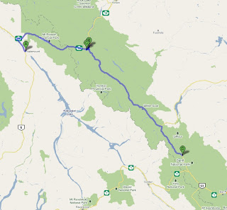
After stretching our visit to the park headquarters as long as possible to (hopefully) allow the clouds to clear and the day to heat up we were back on the road heading east, crossing the border into Alberta's Jasper National Park. Almost immediately the clouds burned off and soon we were guiding our bikes through a fantastic mountain day -- just what we'd been eagerly anticipating!
.JPG) |
| Scott nearly cracks a smile thinking of the road ahead. |
We rolled in to the community of Jasper around Noon, just in time to catch some lunch and a couple beers at Jasper Pizza. The town was very nice: attractive, and to my relief not quite as touristy as I was afraid it might be. The mountains to the northeast looked very peculiar, almost like they were covered in a coating of gray ash, but I've been unable to figure out what that's all about (I didn't get a very good picture of it myself, but you can view a good public domain image of the mountains' coloring here.)
After a couple slices of 'za we made our way up to the Jasper Tramway, hoping to take a ride to a high vantage point atop Whistler's Peak, but our plans were foiled as they had just shut it down when we arrived to fix some electrical problems. So it was back on the road for us...the Icefields Parkway (Hwy 93), which runs basically northwest-to-southeast through the hearts of Jasper and Banff National Parks.
.JPG) |
| The views from the Icefields Parkway were breathtaking. |
.jpg) |
| A panoramic view of the Athabasca Glacier, taken from the deck of the Icefield Interpretive Centre. |
We continued south, soaking up the beautiful day and spectacular views, until we entered Banff National Park and it was time to refill the tanks at basically the only gas station along the way, at Saskatchewan River Crossing, where you can catch Hwy 11 (David Thompson Hwy) and head east towards Edmonton. After filling up we ambled in to the store, where we hoped to find food to fix later for dinner. Unfortunately all we found were some chips, trail mix, and a surprisingly well-stocked small selection of wine. Although for the life of us we couldn't find a corkscrew, we departed with a good bottle of vino snuggled away in Scott's saddlebag. It would later be put to good use.
.JPG) |
| Scott enjoys a beautiful day travelling the Icefields Parkway (photo captured by my ride-along monkey, not by me riding no-hands, looking backwards over my rear fender). |
.JPG) |
| The picturesque motel at our gas stop in Saskatchewan River Crossing almost made us want to stay... |
Back on the road we kept our eyes peeled for a campground. Apparently nearly all the campgrounds had just been shut down for the winter season only the day before, so the pickings were slim; there was only one tent facility open before Lake Louise, Mosquito Creek, nestled between the Icefields Pkwy and the Bow River. We pulled in just after sunset, eager to warm up by a nice camp fire.
After pulling in, selecting our site, and parking the bikes, I walked back to the park entrance to pay our site and firewood fees at the self-serve kiosk. As I approached, another rider had apparently just pulled up on a pretty ratty old BMW F650GS, and still wearing his helmet, looked to be cold and trying to figure the situation out. Since Scott and I had actually claimed a double camp site (where I'd hoped to make prodigious use of the 50ft between my sleep location and Scott's snoring) I turned to the rider and offered to let him share the site and split the fees with us. Low and behold a young female voice answered, saying that her boyfriend was out walking around looking for a site. Already feeling like some sort of creeper I backtracked, quickly paying my fee and reiterating the offer as a scurried off into the darkness.
Surprisingly, only 5 minutes later the couple came idling up to our site. Long story short, they were a mid-20's couple, named Colin and Heidi, and they were returning from a round-trip ride out to Edmonton from Vancouver for a wedding -- a long, cold trip on what was basically a glamorized dirtbike with turn signals, a headlight and a couple small hard saddlebags. A very miniature and underpowered version of what I was riding, alone. Colin was from Vancouver and Heidi was from Sweden. They were real friendly and it was great to have their company! After proper introductions we set about scrounging some soggy kindling and a couple armfuls of firewood, which was provided by the campground. Unfortunately while the wood cutting area was in a pavilion under shelter, all the wood was stacked outside of it, where it had been exposed to days of rain. After literally two to three hours of Colin, Heidi, and I trying to get the completely soaked wood to light (during which time Scott and I put away the bottle of wine plus a flask of whiskey he'd toted along) Scott finally jumped in and got it going in about five minutes. I knew I'd brought him along for something! The temperature quickly plummeted, and after burning through about 30 lbs of kindling and 20 lbs of firewood, we all went our separate ways to snuggle up for a good night's sleep.
Day 5 mileage: 210 mi / 338 km
Total mileage: 1,102 mi / 1,775 km
.JPG)
.jpg)
